Difficulty
Challenging
Duration
15 Days
Max.Altitude
20,955 ft.
Suitable
22 - 50 Years
Distance
84 kms
Accomodation
Tent
Pickup/ Drop
Dehradun
Offloading
Available
Region
Uttarakhand
Know everything About Mt. Black Peak Expedition
The Black Peak Expedition, also known as Kalanag Peak, is a high-altitude adventure located in Uttarkashi, Uttarakhand, rising to 6,387 meters (20,955 feet). Part of the Bandarpoonch massif in the Govind Pashu Vihar National Park, it is one of the most sought-after non-technical peaks in the Indian Himalayas. The peak gets its name from its cobra-like shape (“Kala Nag” means “Black Cobra”) and offers a serious challenge to fit trekkers and budding mountaineers.
The journey begins in Sankri village, passing through scenic campsites like Seema, Dev Thatch, and Ruin Sara Tal, before reaching the Advanced Base Camp and Summit Camp. The route includes glacier walks, snowfields, and steep summit climbs—offering stunning views of Swargarohini, Bandarpoonch, and the Yamunotri Glacier region. While the climb isn’t technical, it does require use of crampons, ropes, and ice axes, making it suitable for those with prior high-altitude trekking experience.
The best time to attempt the Black Peak climb is in the pre-monsoon (May–June) and post-monsoon (September–October) windows when conditions are most stable. The expedition typically takes 15 to 18 days, including travel, acclimatization, and load ferry days. Due to its demanding nature and glacial terrain, it’s rated moderate to difficult, ideal for those preparing for higher peaks or mountaineering goals.
Permits from the Forest Department and Indian Mountaineering Foundation (IMF) are required, which are usually handled by licensed expedition operators. These teams provide guides, porters, technical gear, and safety support, ensuring a structured expedition-style climb.
Overall, the Black Peak Expedition offers a perfect mix of challenge, alpine experience, and Himalayan beauty—ideal for trekkers ready to step into the world of mountaineering. It’s one of India’s best 6,000+ meter climbs for those seeking a true high-altitude adventure without extreme technical demands.
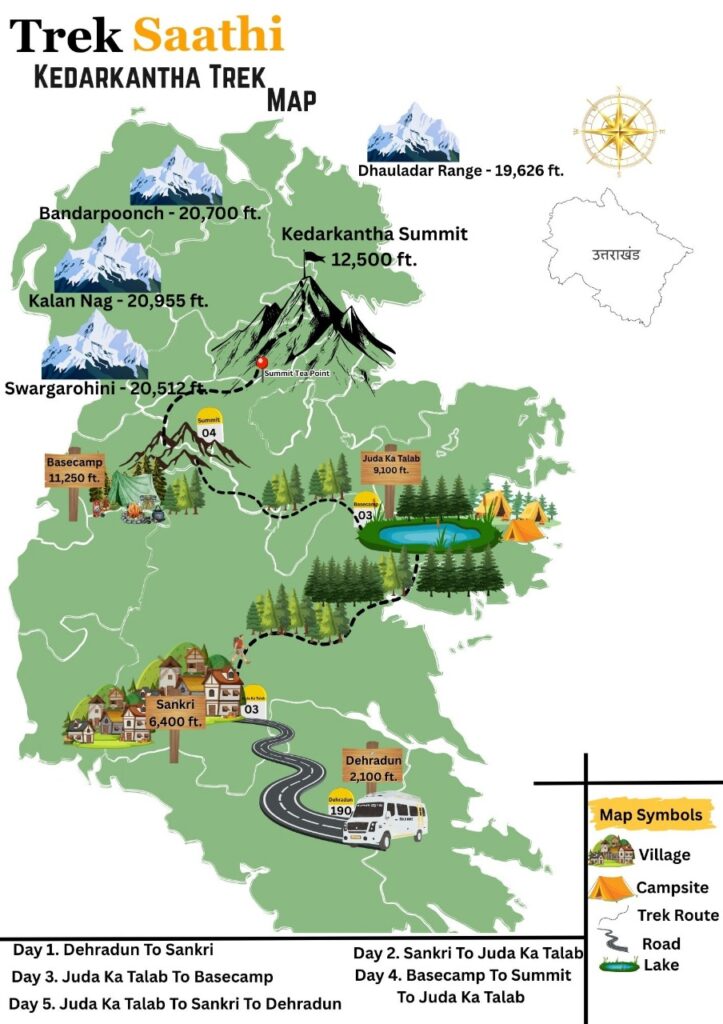
The Kedarkantha Trek is one of the most popular winter treks in the Indian Himalayas, nestled in the Govind Wildlife Sanctuary of Uttarakhand. Standing tall at an altitude of 12,500 feet (3,800 meters), this trek offers breathtaking views of snow-capped peaks, dense pine forests, and charming Himalayan villages. Known for its beginner-friendly trail, the Kedarkantha trek is ideal for both first-time trekkers and experienced adventurers.
The trail begins from the quaint village of Sankri, leading through scenic meadows, frozen lakes, and snow-laden forests. The highlight of the trek is the panoramic summit view of famous peaks like Swargarohini, Bandarpoonch, Black Peak, and Ranglana. With its moderate difficulty level, stunning campsites, and a well-marked trail, Kedarkantha is often regarded as the best winter trek in India.
Perfect for snow trekking from December to April, the Kedarkantha trek promises an unforgettable experience filled with adventure, serenity, and natural beauty.
Mt. Black Peak Expedition Itinerary
Day 1. Dehradun To Sankri
Distance: 190 km
Duration: 7–8 hours by road
Altitude: Dehradun (640 m) to Sankri (1,950 m)
Route: Dehradun – Mussoorie – Kempty Falls – Nainbagh – Damta – Naugaon – Purola – Jarmola Pass – Mori – Netwar – Sankri
Your Black Peak Expedition begins from Dehradun, the capital city of Uttarakhand, which is well-connected by road, rail, and air. After meeting the expedition team and completing the initial briefing, you will board a vehicle for a long but scenic drive towards Sankri village, the base camp for Black Peak (Kala Nag).
The journey takes you through the picturesque Himalayan foothills, with winding roads alongside the Tons River. On the way, you’ll pass through charming hill towns such as Purola, Mori, and Netwar, each offering glimpses of rural Garhwal culture and traditional wooden houses. The dense forests of pine, deodar, and oak add a refreshing touch to the ride.
As you gain altitude, the air becomes crisper and the views more dramatic. The final stretch to Sankri passes through the Govind Pashu Vihar National Park, a protected area famous for its rich biodiversity. Keep your eyes open—you may spot Himalayan birds and lush alpine vegetation on the way.
Upon reaching Sankri (1,950 m) in the evening, you will check in to a guesthouse or homestay. After some tea and snacks, a detailed expedition briefing and gear check will be conducted by your trek leader. You’ll also be introduced to the rest of the team members who will accompany you throughout the challenging journey to Black Peak Summit (6,287 m).
Spend the evening exploring the quaint village of Sankri, interacting with locals, or simply soaking in the views of snow-capped peaks around. Have an early dinner and rest well, as the adventure truly begins tomorrow.
Day 2. Sankri To Seema
Distance: 16 km drive (Sankri to Gangad) + 4 km trek (Gangad to Seema)
Duration: 1.5–2 hours drive + 2–3 hours trek
Altitude: Sankri (1,950 m) → Gangad (2,450 m) → Seema (2,600 m)
Route: Sankri – Taluka – Gangad (drive) – Osla (across the river) – Seema
Your day starts with an early breakfast at Sankri, followed by a scenic 16 km drive to Gangad village. The route passes through Taluka, a small road-head settlement, before continuing further on a bumpy but adventurous stretch through thick forests of pine and deodar. The drive itself is breathtaking as you move deeper into the Govind Pashu Vihar National Park, with the Tons River flowing alongside.
Upon reaching Gangad (2,450 m), the drive ends, and your trek begins. Gangad is a traditional wooden village offering a first glimpse of the unique Himalayan lifestyle and architecture. From here, it’s a 4 km trek to Seema, a gradual ascent on a trail that runs parallel to the Tons River.
Across the river, you will spot the famous Osla village, known for its mythological Someshwar Temple dedicated to Duryodhana. The trek offers mesmerizing views of terraced fields, wildflowers, and thick forest cover before opening into the Seema campsite (2,600 m).
Seema is not a permanent village but a cluster of campsites and a Forest Rest House, making it a popular halt for trekkers heading to Har Ki Dun, Ruinsara, and Black Peak Base Camp. Spend the evening enjoying the serene surroundings before dinner and overnight stay in tents.
Day 3.Seema to Rainbasera
Distance: 9 km trek
Duration: 5–6 hours
Altitude: Seema (2,600 m) → Rainbasera (3,100 m)
Route: Seema – Debshu Bugyal – Ruinsara River crossing – Rainbasera campsite
After breakfast at Seema, you begin your trek towards Rainbasera, one of the most beautiful and serene campsites on the Black Peak Expedition trail. The trail gradually climbs up through thick forests of pine and oak, before opening into the picturesque Debshu Bugyal (meadow). From here, you get your first clear views of the snow-clad Swargarohini and Black Peak ranges, motivating you for the days ahead.
The path from Debshu Bugyal then descends steeply towards the Ruinsara River, where you cross a wooden bridge to reach the other side. The sound of the gushing river and the raw wilderness of the valley add to the adventure. After crossing the river, the trail follows a series of ascents and descents through rocky sections, lush forests, and grassy clearings.
By afternoon, you reach Rainbasera (3,100 m), a small flat clearing beside the Ruinsara River. The campsite is surrounded by tall cliffs and alpine forests, making it an ideal resting point before pushing higher into the valley. The soothing sound of the river and the pristine natural surroundings create a peaceful atmosphere, perfect for acclimatization.
Enjoy hot meals, settle into your tents, and rest well under a blanket of stars.
Day 4. Rainbasera to Ruinsara Tal
Distance: 7 km trek
Duration: 4–5 hours
Altitude: Rainbasera (3,100 m) → Ruinsara Tal (3,600 m)
Route: Rainbasera – Alpine forest trail – River crossings – Meadows – Ruinsara Lake
After an early breakfast at Rainbasera, you start the gradual but scenic trek to Ruinsara Tal (Ruinsara Lake). The trail runs along the Ruinsara River, weaving through a mix of alpine forests, grassy meadows, and rocky patches. Compared to the previous day, today’s trek is relatively short but offers spectacular Himalayan views.
As you gain altitude, the forest begins to thin out and wide meadows open up, offering clear vistas of towering peaks like Swargarohini (6,252 m), Bandarpoonch (6,316 m), Dhumdhar Kandi Pass, and Black Peak (Kala Nag, 6,287 m). You’ll cross a few wooden bridges over streams before reaching the final ascent to the lake.
By afternoon, you arrive at the serene Ruinsara Tal (3,600 m), a glacial lake surrounded by meadows and snow-covered peaks. Considered sacred by locals, the lake holds deep cultural and spiritual significance. The calm waters of the lake reflect the mighty Himalayas, creating a picture-perfect campsite.
This is also an important acclimatization stop for trekkers and climbers heading towards Black Peak Base Camp. Spend the evening exploring the meadow, capturing photographs of the surrounding Himalayan panorama, and resting by the lakeside before dinner.
Day 5. Ruinsara Tal to Kyarkoti
Distance: 7 km trek
Duration: 5–6 hours
Altitude: Ruinsara Tal (3,600 m) → Kyarkoti (3,800 m)
Route: Ruinsara Tal – Banderpoonch & Swargarohini viewpoints – Boulder sections – Alpine meadows – Kyarkoti
After breakfast at the stunning Ruinsara Tal campsite, you begin your trek towards Kyarkoti (3,800 m), the designated base camp for Black Peak Expedition. The trail is rugged, moving through alpine meadows, scattered boulders, and glacial moraines.
The initial section of the trek offers breathtaking views of surrounding Himalayan giants like Swargarohini, Bandarpoonch, Dhumdhar Kandi Pass, and Black Peak itself, which now begins to appear much closer and more prominent. The route gradually ascends with occasional steep sections and rocky terrain, making it a moderately challenging day.
As you continue, you’ll pass through open pastures where shepherds often bring their livestock during summer. The lush grasslands, combined with the backdrop of snow-capped peaks, create a surreal Himalayan landscape.
By afternoon, you reach Kyarkoti (3,800 m), a wide meadow surrounded by lofty mountains and glacial streams. This is the Base Camp for Black Peak (Kala Nag, 6,287 m), where you’ll set up tents and spend the next few days preparing for the summit push.
Evening time will be dedicated to rest, acclimatization, and a briefing session about the upcoming load-ferry and technical climbing sections. From Kyarkoti, you get majestic views of Black Peak’s steep face, which will be your ultimate challenge in the coming days.
Day 6. Kyarkoti To Advanced Base Camp (ABC)
Distance: 4–5 km trek
Duration: 4–5 hours
Altitude: Kyarkoti (3,800 m) → Advance Base Camp (4,200 m)
Route: Kyarkoti – Glacial boulder section – Moraine ridges – Advance Base Camp
After breakfast at Kyarkoti Base Camp (3,800 m), you begin the crucial climb towards Advance Base Camp (ABC), which is the staging point for higher camps on the Black Peak Expedition. The trek today is shorter in distance but more challenging because the route involves boulder-strewn glacial terrain, loose moraines, and steep ascents.
The trail starts with a gradual climb through alpine meadows before quickly entering rocky glacial zones. The vegetation thins out as you move higher, and the oxygen levels start dropping, making acclimatization even more important. Throughout the trek, you’ll be rewarded with closer views of Black Peak (Kala Nag, 6,287 m), Bandarpoonch Massif, and Swargarohini Peaks dominating the skyline.
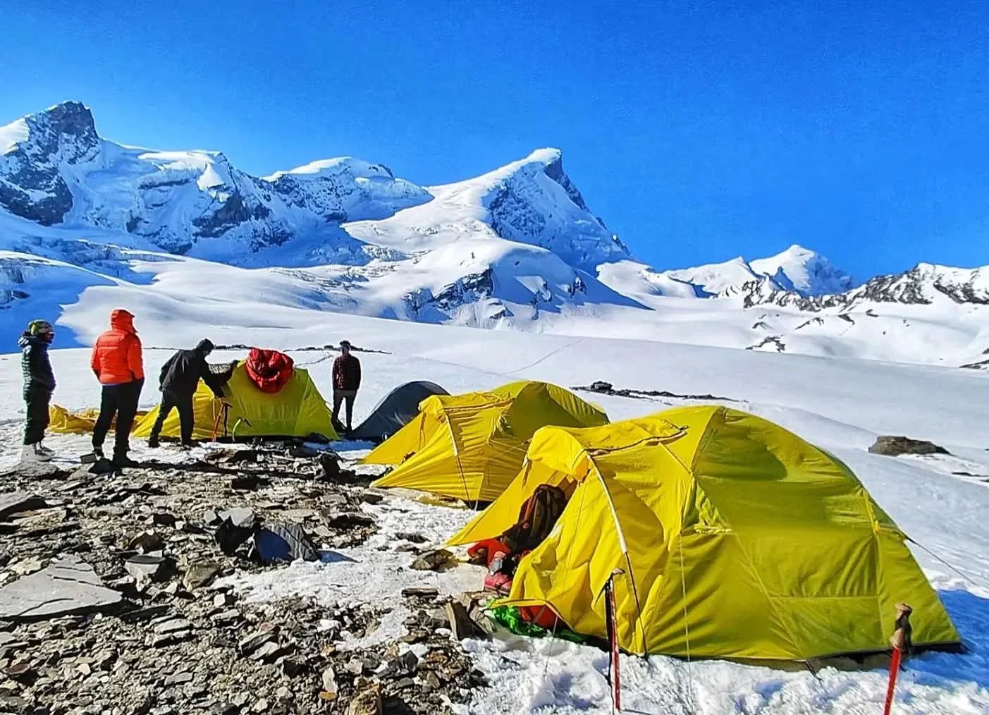
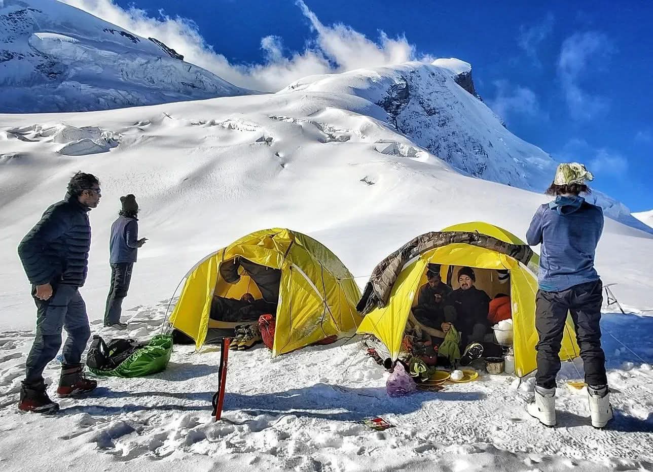
After 4–5 hours of steady climbing, you arrive at the Advance Base Camp (4,200 m). The campsite is located on a rocky moraine field, surrounded by glacial streams and towering Himalayan peaks. This is a significant point in the expedition, as all load ferries, acclimatization rotations, and technical training sessions will be carried out from here.
In the evening, the expedition leader will conduct a gear check and basic mountaineering practice session, including the use of crampons, ice axes, harnesses, and ropes. The team will also prepare for setting up higher camps (Camp 1, Summit Camp) in the following days.
Day 7. Rest/ Acclimatization/ Load Ferry
Distance: 2–3 km (load ferry to higher altitude and back)
Duration: 4–5 hours (including load ferry + practice)
Altitude: Advance Base Camp (4,200 m) → Higher altitude ferry point (~4,500 m) → Return to Advance Base Camp (4,200 m)
Route: Advance Base Camp – Glacier sections – Load ferry zone – Return to Advance Base Camp
Today is a dedicated acclimatization and load ferry day at Advance Base Camp (4,200 m). In high-altitude expeditions like Black Peak (Kala Nag, 6,287 m), proper acclimatization is critical for success and safety.
The team begins the day with a load ferry — carrying essential equipment (like tents, ropes, food, fuel, and technical gear) to a higher point on the route towards Camp 1 (~4,500 m). This climb helps the body adapt to lower oxygen levels while lightening the load for upcoming summit days. After dropping the loads at the designated cache point, climbers return to Advance Base Camp for rest and recovery.
Apart from the load ferry, this day is also used for technical training and practice. The expedition leader will conduct drills on using mountaineering gear such as crampons, ice axes, jumar ascenders, harnesses, and rope techniques. You’ll also practice ascending and descending on snow slopes, glacier travel, and team rope movement—skills that will be vital in the higher, more technical sections.
The evening is spent resting, hydrating, and mentally preparing for the next phase, as you will be moving to Camp 1 soon.
Day 8. Advanced Base Camp (ABC) to Camp 1
Distance: 4–5 km trek/climb
Duration: 5–6 hours
Altitude: Advance Base Camp (4,200 m) → Camp 1 (4,800 m)
Route: Advance Base Camp – Glacier approach – Moraine & boulder sections – Steep snow slopes – Camp 1
After breakfast at Advance Base Camp (4,200 m), you start the ascent towards Camp 1 (4,800 m). Today marks your first push into higher altitude zones, where the terrain becomes significantly more demanding.
The route begins with a gradual climb across moraine ridges and loose boulders, requiring careful foot placement. Soon, you step onto the glacier, where the trail continues over patches of ice, snow bridges, and rocky ridgelines. From here, the ascent becomes steeper, and you’ll need to use technical equipment such as crampons, harnesses, ice axe, and ropes under the guidance of your expedition leader.
Throughout the climb, the views of Black Peak’s massive face get closer and more intimidating, with surrounding giants like Swargarohini and Bandarpoonch adding to the grandeur. The oxygen levels drop considerably at this height, making slow and steady climbing essential.
By afternoon, you reach Camp 1 (4,800 m), set on a snowfield with panoramic views of glaciers and peaks. This campsite will serve as the staging point for Summit Camp and the final summit push. After setting up tents, the rest of the day is for rest, hydration, and acclimatization.
Day 9. Camp 1 to Summit Camp
Distance: 3–4 km climb
Duration: 4–5 hours
Altitude: Camp 1 (4,800 m) → Summit Camp (5,200 m)
Route: Camp 1 – Steep glacier section – Snow ridges – Ice slopes – Summit Camp
After an early breakfast at Camp 1 (4,800 m), you begin the challenging climb to Summit Camp (5,200 m). Though the distance is relatively short, the route is technical and physically demanding, as you gain nearly 400 m of altitude in a high-glacier environment.
The trail starts with a steady ascent across a vast glacier section, where you will rope up in teams for safety. As you move higher, the terrain turns into steep snow ridges and icy slopes, requiring precise use of crampons, ice axe, and fixed ropes. The expedition leader and technical team fix ropes on tricky sections for safe passage.
Throughout the climb, you’ll be treated to jaw-dropping views of Swargarohini Massif, Bandarpoonch, Dhumdhar Kandi Pass, and Black Peak’s imposing summit face looming ahead. The thin air makes every step more challenging, so maintaining a slow, steady pace is essential.
By afternoon, you reach Summit Camp (5,200 m), located on a snowfield beneath the final Black Peak summit ridge. This is one of the coldest and most exposed campsites of the expedition, with icy winds and sub-zero temperatures even during daytime.
The rest of the day is spent resting, hydrating, and preparing gear for the midnight summit push. After an early dinner, the team goes to sleep early for a few hours, as you’ll wake up around midnight to begin the climb to the Black Peak summit (6,287 m).
Day 10. Summit Camp to Summit Attempt (Black Peak)
Distance: 8–9 km (ascent + descent)
Duration: 12–15 hours (round trip)
Altitude: Summit Camp (5,200 m) → Black Peak Summit (6,287 m) → return to Summit Camp (5,200 m)
Route: Summit Camp – Steep snow ridges – Glacial traverse – Summit ridge – Black Peak Summit – Descend same route – Summit Camp
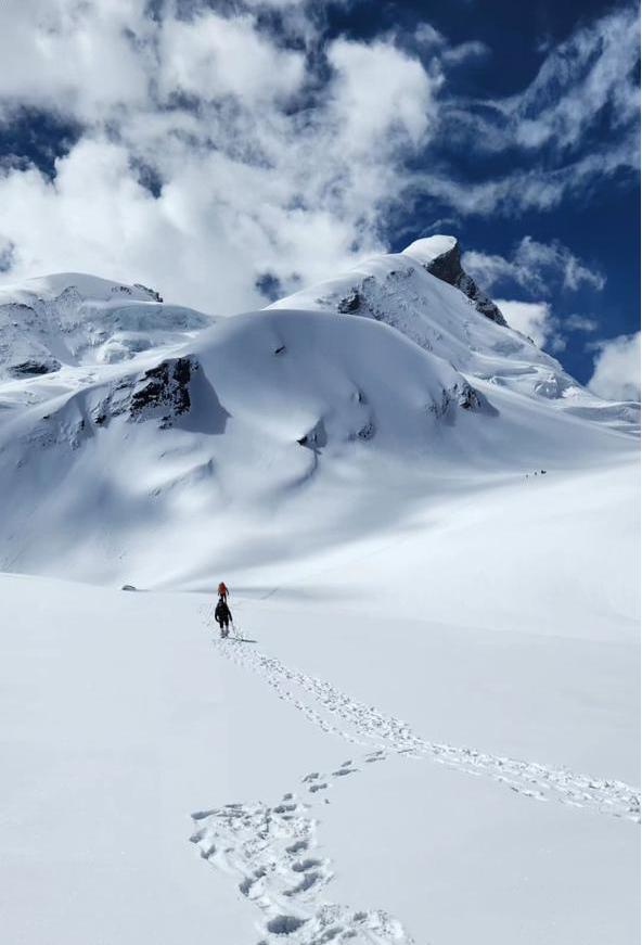
This is the biggest and toughest day of the Black Peak Expedition — your summit attempt. The team wakes up around midnight (11:30 pm – 12:00 am) and prepares for the final climb under the star-lit Himalayan sky. After a quick high-calorie meal and gear check, you begin the summit push with headlamps on.
The Ascent
The climb starts with a steep snow ridge straight out of Summit Camp, where you move roped up with your team.
You then traverse a wide glacier section, navigating crevasses and gradually gaining altitude.
As dawn approaches, the terrain becomes steeper, with ice slopes of 50–60 degrees where fixed ropes and jumars are used for safety.
The final stretch involves climbing along the exposed summit ridge, a narrow snowy path with steep drops on both sides. This is the most technical and challenging part, demanding full focus, stamina, and mountaineering skills.
At the Summit (6,287 m / 20,623 ft)
By early morning, after 6–8 hours of climbing, you stand on the summit of Black Peak (Kalanag) at 6,287 m, one of the highest and most majestic peaks in the Bandarpunch range of the Garhwal Himalayas.
From the top, you are rewarded with 360° panoramic views of some of the greatest Himalayan peaks:
Swargarohini, Bandarpoonch, Satopanth, Kedarnath Dome, Shivling, and Gangotri ranges stretching endlessly.
The feeling of accomplishment is overwhelming as you’ve conquered one of Uttarakhand’s most technical and challenging 6,000er expeditions.
The Descent
After spending 15–20 minutes at the summit (depending on weather), the descent begins on the same route. While descending, extra care is required on steep icy slopes and the exposed ridge. The technical team assists with rappelling and rope support.
By late afternoon, you return exhausted but triumphant to Summit Camp (5,200 m), where you rest and recover.
Day 11. Summit Camp to Base Camp
Distance: 10–11 km (descent)
Duration: 6–7 hours
Altitude: Summit Camp (5,200 m) → Base Camp (4,200 m)
Route: Summit Camp – Camp 1 ridge – Advance Base Camp (ABC) – Kyarkoti meadows – Base Camp
After the thrilling summit push on the previous day, Day 11 of the Black Peak Expedition is dedicated to the descent from Summit Camp to Base Camp. The trail retraces the route taken earlier but feels very different, as the pressure of the climb is now replaced with the joy of accomplishment.
The day begins with a careful descent from Summit Camp through technical snow and ice patches. The first checkpoint is Camp 1 (5,000 m), where the team halts briefly to rest and gather any equipment left behind during the ascent. From here, the descent continues to Advance Base Camp (4,600 m), crossing ridges and glacier stretches.
As you progress further down, the stark icy terrain gives way to the green expanse of Kyarkoti meadows. After days of being in the harsh upper reaches, this return to alpine beauty feels refreshing. The final stretch leads to Base Camp (4,200 m), where the thicker air and more hospitable environment provide a sense of comfort and relief.
Reaching Base Camp is always a celebratory moment. Trekkers regroup, share summit stories, and enjoy warm meals, cherishing the success of having scaled Black Peak. The evening is reserved for rest and preparation for the descent towards Ruinsara Tal and Seema in the days ahead.
Day 12. Kyarkoti Base Camp to Ruinsara Tal
Distance: 8–9 km (descent)
Duration: 5–6 hours
Altitude: Base Camp (4,200 m) → Ruinsara Tal (3,600 m)
Route: Base Camp – Kyarkoti meadows – glacier moraine – alpine trail – Ruinsara Tal
After several challenging days in the high-altitude zones, Day 12 offers a refreshing descent from Base Camp at Kyarkoti (4,200 m) down to the serene Ruinsara Tal (3,600 m). The trek covers around 8–9 km and takes nearly 5–6 hours, with a gradual drop in altitude that makes breathing noticeably easier.
The journey begins by leaving the rugged moraine and glacier fields behind, retracing the path through Kyarkoti’s alpine meadows. Trekkers are greeted with vibrant landscapes, fresh air, and a sense of relief after the intense summit and base camp days. The trail winds through a mix of rocky sections and grassy patches, offering occasional views back towards the mighty Black Peak and its surrounding ranges.
As you approach Ruinsara Tal, the terrain softens, opening into one of the most enchanting alpine lakes in Uttarakhand. Known for its crystal-clear waters and panoramic views of snow-clad peaks, Ruinsara Tal is a sacred spot and a perfect campsite for trekkers. After setting up camp, the rest of the day can be spent exploring the lakeside, relaxing, and reflecting on the incredible summit achievement.
Evening at Ruinsara is magical — with golden reflections on the lake, the backdrop of towering mountains, and a sky full of stars. This descent day feels like a reward, blending natural beauty with a deep sense of accomplishment.
Day 13. Ruinsara Tal to Seema
Distance: 10–11 km (descent)
Duration: 5–6 hours
Altitude: Ruinsara Tal (3,600 m) → Seema (2,600 m)
Route: Ruinsara Tal – alpine meadows – dense pine/oak forest – river crossings – Seema village campsite
After a peaceful night by the enchanting Ruinsara Tal, the expedition continues with a steady descent back to Seema (2,600 m). Covering 10–11 km over 5–6 hours, this stretch transitions from the open alpine landscape near the lake to thick forests and riverside trails.
The trek begins with gentle descents through meadows filled with wildflowers (in summer) and a backdrop of Himalayan peaks that gradually fade as you move lower. Soon, the trail enters a forest belt of pine, oak, and rhododendron, where the air feels warmer and denser compared to the crisp, thin air of higher altitudes. You’ll also encounter small wooden bridges and river crossings, adding variety to the descent.
By afternoon, you arrive at Seema, a familiar campsite near the Supin River. Nestled against terraced fields and traditional wooden houses, Seema offers a cultural touch of the Garhwali lifestyle. The camp here feels lively and refreshing after many days in isolation among glaciers and rocky slopes.
Evening at Seema is spent unwinding by the riverside, enjoying warm meals, and sharing stories of the summit adventure with fellow trekkers. This marks the transition from the high-altitude mountaineering phase back to the welcoming villages of the Har Ki Dun valley.
Day 14. Seema To Gangad and Drive to Sankri
Distance (Trek): 3–4 km (descent)
Duration (Trek): 1–2 hours
Altitude: Seema (2,600 m) → Gangad (2,350 m) → Sankri (1,950 m)
Route: Seema – riverside forest trail – Gangad village – drive along Supin River valley – Sankri
The final day of the Black Peak Expedition begins with a short and scenic descent from Seema to Gangad village, covering 3–4 km in just about 1–2 hours. The trail winds through pine and deodar forests with the soothing sound of the Supin River flowing alongside. Soon, you reach Gangad (2,350 m), a charming Himalayan settlement with traditional wooden houses, terraced farms, and a backdrop of lush greenery.
From Gangad, vehicles arranged by the expedition team will be waiting to drive you back to Sankri (1,950 m). The road journey descends gradually through the beautiful Supin valley, passing by quaint villages and apple orchards. Along the way, you’ll notice the stark contrast between the high-altitude alpine landscapes left behind and the vibrant green valleys that welcome you back to civilization.
By late afternoon, you arrive at Sankri, the starting and ending point of the Black Peak Expedition. Here, you can finally rest in a comfortable guesthouse, enjoy freshly prepared local meals, and celebrate the successful completion of one of the most challenging expeditions in the Garhwal Himalayas.
This marks the end of your Black Peak (Kala Nag) Expedition, a journey that combined adventure, endurance, and the raw beauty of the Indian Himalayas.
Day 15. Sankri To Dehradun
Distance (Drive): 190–200 km
Duration (Drive): 8–9 hours by road
Altitude: Sankri (1,950 m) → Mori → Purola → Mussoorie → Dehradun (640 m)
Route: Sankri – Taluka road – Mori (Tons River) – Purola – Naugaon – Mussoorie – Dehradun
After breakfast at Sankri, you bid farewell to the mountains and begin your long road journey back to Dehradun. The drive is approximately 190–200 km, taking around 8–9 hours, and passes through some of the most picturesque valleys of Uttarakhand.
The road winds down from Sankri, hugging the Tons River and passing through pine and deodar forests. You’ll cross Mori and Purola, two beautiful hill towns known for their apple orchards and scenic landscapes. As you drive further, the road opens up to views of rolling meadows, terraced fields, and charming villages.
By afternoon, you’ll pass Naugaon and continue via the winding hill roads through Mussoorie, the famous “Queen of Hills,” before finally descending to Dehradun (640 m) by evening.
With this, your Black Peak Expedition (Kala Nag Expedition) officially comes to an end. You part ways with your team, carrying unforgettable memories of high-altitude camps, the icy climb to the summit, and the breathtaking Himalayan landscapes that defined this expedition.
Mt. Black Peak Expedition Cost Terms
What's Included
1. Transportation
Shared transportation from Dehradun to Sankri and return
Vehicles used: Tempo Traveller, Bolero, or Sumo depending on group size
Pickup and drop point: ISBT Dehradun or Dehradun Railway Station
Note: Some budget packages may exclude transport – check before booking
2. Accommodation
1 night stay in a guest house or homestay at Sankri (on arrival)
Expedition camping stay in alpine tents during the trek
Triple sharing tents with sleeping bags, foam mats, and liners provided
Clean toilet tents and separate kitchen/dining tents at campsites
3. Meals
All vegetarian meals from Day 1 dinner to final day breakfast
Morning tea/coffee, hot lunch and dinner, and light evening snacks
Hygienic, nutritious Indian meals prepared by trained trek cooks
Egg options may be available in some packages
4. Trekking Staff
Experienced expedition leader and certified mountain guide
Support team including cook, helpers, and porters/mules for common gear
Professional staff trained in high-altitude safety and emergency response
5. Trekking Equipment
Waterproof alpine tents, dining tents, and toilet tents
Sub-zero rated sleeping bags, liners, and foam mattresses
Microspikes and gaiters provided during snow conditions (seasonal)
Group gear, utensils, and equipment for cooking and serving meals
6. Additional Inclusions
Trekking permits and forest entry fees
Entry to Govind Pashu Vihar National Park & Wildlife Sanctuary
Basic first-aid kit with oximeter for daily oxygen level checks
Oxygen cylinder available for emergencies (in select packages)
What's Excluded
5% GST on the total package cost
Travel to and from Dehradun (flights, trains, buses)
Meals during transit (while traveling to/from Sankri or Dehradun)
Personal trekking gear (shoes, jackets, backpack, walking stick, etc.)
Backpack offloading charges (if you don’t want to carry your own bag)
Travel or medical insurance
Emergency evacuation charges (in case of illness, injury, or bad weather)
Extra snacks, cold drinks, and bottled water
Tips for guides, porters, and staff (optional)
Personal expenses (laundry, phone recharge, medicines, etc.)
Higher forest/permit fees for foreign nationals
Anything not mentioned under “inclusions”
Mt. Black Peak Expedition Packages Costs
Sankri To Sankri
₹ 80,500/- PP
₹ 75,999/-PP
- 14 Nights Accomodation
- Breakfast, Lunch, Dinner & Sbacks
- Forest Permit & Fees
- Trek Guide
- Trekking Central Equipments
- Safty & First Aid
Dehradun To Dehradun
₹ 85,500/- PP
₹ 79,999/-PP
- Dehradun To Dehradun Transport
- 14 Nights Accomodation
- Breakfast, Lunch, Dinner & Sbacks
- Forest Permit & Fees
- Trek Guide
- Trekking Central Equipments
- Safty & First Aid
Delhi To Delhi
₹ 90,500/- PP
₹ 83,999/-PP
- Delhi To Delhi Transport
- 14 Nights Accomodation
- Breakfast, Lunch, Dinner & Sbacks
- Forest Permit & Fees
- Trek Guide
- Trekking Central Equipments
- Safty & First Aid
Mt. Black Peak Expedition Terms And Conditions
Advance Booking & Payment
Advance Payment: 20% of the trek cost is to be paid at the time of booking to confirm your slot.
Remaining Payment: The balance 80% of the trek cost must be paid at the time of pickup/start of the trek.
Refund & Cancellation Policy
45 days or more before the trek start date: 90% of the trek cost will be refunded.
30 to 44 days before the trek start date: 50% of the trek cost will be refunded.
21 to 29 days before the trek start date: 25% of the trek cost will be refunded.
15 to 20 days before the trek start date: No refund will be provided.
Less than 15 days before the trek start date: No refund will be provided.
Mt. Black Peak Expedition Departures Dates
November 2025
18 Nov – 22 Nov
24 Nov – 27 Nov
28 Nov – 2 Dec
30 Nov – 4 Dec
Available
Available
Available
Available
Book Now
Book Now
Book Now
Book Now
December 2025
1 Dec – 5 Dec
2 Dec – 6 Dec
3 Dec – 7 Dec
4 Dec – 8 Dec
5 Dec – 9 Dec
6 Dec – 10 Dec
7 Dec – 11 Dec
8 Dec – 12 Dec
9 Dec – 13 Dec
10 Dec – 14 Dec
11 Dec – 15 Dec
12 Dec – 16 Dec
13 Dec – 17 Dec
14 Dec – 18 Dec
15 Dec – 19 Dec
16 Dec – 20 Dec
17 Dec – 21 Dec
18 Dec – 22 Dec
19 Dec – 23 Dec
20 Dec – 24 Dec
21 Dec – 25 Dec
22 Dec – 26 Dec
23 Dec – 27 Dec
24 Dec – 28 Dec
25 Dec – 29 Dec
26 Dec – 30 Dec
27 Dec – 31 Dec
28 Dec – 1 Jan
29 Dec – 2 Jan
30 Dec – 3 Jan
31 Dec – 4 Jan
Available
Available
Available
Available
Available
Available
Available
Available
Available
Available
Available
Available
Available
Available
Available
Available
Available
Available
Available
Available
Available
Available
Available
Available
Available
Available
Available
Available
Available
Available
Available
Book Now
Book Now
Book Now
Book Now
Book Now
Book Now
Book Now
Book Now
Book Now
Book Now
Book Now
Book Now
Book Now
Book Now
Book Now
Book Now
Book Now
Book Now
Book Now
Book Now
Book Now
Book Now
Book Now
Book Now
Book Now
Book Now
Book Now
Book Now
Book Now
Book Now
Book Now
January 2025
1 Jan – 5 Jan
2 Jan – 6 Jan
3 Jan – 7 Jan
4 Jan – 8 Jan
5 Jan – 9 Jan
6 Jan – 10 Jan
7 Jan – 11 Jan
8 Jan – 12 Jan
9 Jan – 13 Jan
10 Jan – 14 Jan
11 Jan – 15 Jan
12 Jan – 16 Jan
13 Jan – 17 Jan
14 Jan – 18 Jan
15 Jan – 19 Jan
16 Jan – 20 Jan
17 Jan – 21 Jan
18 Jan – 22 Jan
19 Jan – 23 Jan
20 Jan – 24 Jan
21 Jan – 25 Jan
22 Jan – 26 Jan
23 Jan – 27 Jan
24 Jan – 28 Jan
25 Jan – 29 Jan
26 Jan – 30 Jan
27 Jan – 31 Jan
28 Jan – 1 Feb
29 Jan – 2 Feb
30 Jan – 3 Feb
31 Jan – 4 Feb
Available
Available
Available
Available
Available
Available
Available
Available
Available
Available
Available
Available
Available
Available
Available
Available
Available
Available
Available
Available
Available
Available
Available
Available
Available
Available
Available
Available
Available
Available
Available
Book Now
Book Now
Book Now
Book Now
Book Now
Book Now
Book Now
Book Now
Book Now
Book Now
Book Now
Book Now
Book Now
Book Now
Book Now
Book Now
Book Now
Book Now
Book Now
Book Now
Book Now
Book Now
Book Now
Book Now
Book Now
Book Now
Book Now
Book Now
Book Now
Book Now
Book Now
Februrary 2025
1 Feb – 5 Feb
2 Feb – 6 Feb
3 Feb – 7 Feb
4 Feb – 8 Feb
5 Feb – 9 Feb
6 Feb – 10 Feb
7 Feb – 11 Feb
8 Feb – 12 Feb
9 Feb – 13 Feb
10 Feb – 14 Feb
11 Feb – 15 Feb
12 Feb – 16 Feb
13 Feb – 17 Feb
14 Feb – 18 Feb
15 Feb – 19 Feb
16 Feb – 20 Feb
17 Feb – 21 Feb
18 Feb – 22 Feb
19 Feb – 23 Feb
20 Feb – 24 Feb
21 Feb – 25 Feb
22 Feb – 26 Feb
23 Feb – 27 Feb
24 Feb – 28 Feb
25 Feb – 1 Mar
26 Feb – 2 Mar
27 Feb – 3 Mar
28 Feb – 4 Mar
Available
Available
Available
Available
Available
Available
Available
Available
Available
Available
Available
Available
Available
Available
Available
Available
Available
Available
Available
Available
Available
Available
Available
Available
Available
Available
Available
Available
Book Now
Book Now
Book Now
Book Now
Book Now
Book Now
Book Now
Book Now
Book Now
Book Now
Book Now
Book Now
Book Now
Book Now
Book Now
Book Now
Book Now
Book Now
Book Now
Book Now
Book Now
Book Now
Book Now
Book Now
Book Now
Book Now
Book Now
Book Now
March 2025
1 Mar – 5 Mar
2 Mar – 6 Mar
3 Mar – 7 Mar
4 Mar – 8 Mar
5 Mar – 9 Mar
6 Mar – 10 Mar
7 Mar – 11 Mar
8 Mar – 12 Mar
9 Mar – 13 Mar
10 Mar – 14 Mar
11 Mar – 15 Mar
12 Mar – 16 Mar
13 Mar – 17 Mar
14 Mar – 18 Mar
15 Mar – 19 Mar
16 Mar – 20 Mar
17 Mar – 21 Mar
18 Mar – 22 Mar
19 Mar – 23 Mar
20 Mar – 24 Mar
21 Mar – 25 Mar
22 Mar – 26 Mar
23 Mar – 27 Mar
24 Mar – 28 Mar
25 Mar – 29 Mar
26 Mar – 30 Mar
27 Mar – 31 Mar
28 Mar – 1 Apr
29 Mar – 2 Apr
30 Mar – 3 Apr
31 Mar – 4 Apr
Available
Available
Available
Available
Available
Available
Available
Available
Available
Available
Available
Available
Available
Available
Available
Available
Available
Available
Available
Available
Available
Available
Available
Available
Available
Available
Available
Available
Available
Available
Available
Book Now
Book Now
Book Now
Book Now
Book Now
Book Now
Book Now
Book Now
Book Now
Book Now
Book Now
Book Now
Book Now
Book Now
Book Now
Book Now
Book Now
Book Now
Book Now
Book Now
Book Now
Book Now
Book Now
Book Now
Book Now
Book Now
Book Now
Book Now
Book Now
Book Now
Book Now
April 2025
1 Apr – 5 Apr
5 Apr – 9 Apr
9 Apr – 13 Apr
17 Apr – 21 Apr
26 Apr – 30 Apr
Available
Available
Available
Available
Available
Book Now
Book Now
Book Now
Book Now
Book Now
How To Reach Mt. Black Peak Expedition
Pickup Place
Prince Chowk, Dehradun
Pickup Time
06:30 AM - 07:30 AM
Drop Place
Prince Chowk, Dehradun
Drop Time
07:30 PM - 08:30 PM
Dehradun is well-connected to major cities of India by air, train, and road.
By Air:
- The nearest airport is Jolly Grant Airport, Dehradun (DED), located 25 km from the city center.
- Direct flights operate from Delhi, Mumbai, Bengaluru, and other metro cities.
By Train:
- Dehradun Railway Station connects to cities like Delhi, Kolkata, Lucknow, and Varanasi.
- Popular trains include Dehradun Express, Nanda Devi Express, and Shatabdi Express (from Delhi).
By Road:
- Dehradun is accessible by buses and taxis from Delhi (250 km / 6–7 hours).
- Regular Volvo and state transport buses run from ISBT Kashmiri Gate, Delhi to Dehradun.
Mt. Black Peak Expedition Fitness
The Black Peak (Kala Nag) Expedition is a challenging high-altitude climb that requires excellent physical endurance, stamina, and mental preparation. At 6,387 m (20,955 ft), this peak is far more demanding than regular Himalayan treks. To ensure safety and success, trekkers must follow a disciplined fitness plan well in advance.
1. Endurance
You should be able to jog/run 5 km in 30–35 minutes comfortably.
Practice long walks with a backpack (8–10 kg load) to simulate trekking conditions.
Train on inclined surfaces or stair climbing to build uphill stamina.
2. Strength & Core Training
Include squats, lunges, push-ups, and planks in your daily routine.
Focus on leg strength to handle steep ascents and descents.
Strong core and back muscles will help with balance and carrying loads.
3. Cardiovascular Fitness
Aerobic exercises like running, cycling, or swimming are highly recommended.
Aim for 45–60 minutes of cardio, 4–5 days a week.
Interval training (HIIT) can help improve lung capacity, which is crucial at high altitudes.
4. Flexibility & Balance
Practice yoga or stretching exercises to improve flexibility and reduce the risk of injury.
Breathing exercises like Pranayama are useful for oxygen efficiency at high altitudes.
5. Acclimatization & Mental Preparation
The expedition involves camping above 5,000 m for several days.
Be prepared for extreme weather, snow conditions, and long trekking hours.
A positive mindset and mental resilience are as important as physical strength.
Recommended Training Schedule
Start at least 3–4 months before the expedition.
Gradually increase your running distance, strength sets, and backpack load.
Try to include weekend hikes/treks in hilly terrain if possible.
Mt. Black Peak Expedition Packing List
Thermals (top & bottom)
2–3 quick-dry T-shirts (full sleeves preferred)
2 fleece jackets / woollen sweaters
1 down jacket (for winter)
Waterproof & windproof jacket with hood
2 trekking pants (quick-dry)
1 warm/fleece pant (for nights)
Woollen cap / beanie
Sun cap (for daytime)
Neck gaiter / balaclava
Inner gloves (wool/fleece)
Outer waterproof gloves
3–4 pairs trekking socks (wool + synthetic)
1 pair thick wool socks (for night)
Trekking shoes (ankle-high, waterproof, good grip, sturdy sole)
3–4 pairs trekking socks (wool + synthetic blend)
1 pair thick woollen socks (for sleeping at night)
Camp shoes / slippers (lightweight, for evenings at campsite)
50–60 L trekking backpack (with rain cover)
15–20 L daypack (optional for summit day)
Trekking pole
Rain cover for backpack
Headlamp with extra batteries
Water bottles (2 × 1L) or hydration bladder (2L)
UV-protection sunglasses / snow goggles
Sun cap / woollen cap
Buff / neck gaiter / balaclava
Inner fleece gloves + outer waterproof gloves
Power bank
Camera / GoPro (optional)
Toothbrush & small toothpaste
Biodegradable soap / facewash
Hand sanitizer
Wet wipes & tissues
Toilet roll
Lip balm (essential, cold weather dries lips)
Sunscreen (SPF 40+ recommended)
Moisturizer / cold cream
Small towel / microfiber towel
Sanitary napkins / tampons / menstrual cup (for women trekkers)
Deodorant (travel size)
Nail cutter & small comb
Personal prescribed medicines
Diamox (for altitude – doctor’s advice needed)
Crocin / Dolo 650 (fever, mild pain)
Combiflam / Brufen (body ache)
Avomine (motion sickness)
Digene (acidity)
ORS / Electral (dehydration)
Band-aids & crepe bandage
Antiseptic cream / Betadine
Pain relief spray
Government photo ID (Aadhar / Passport / Driving License / Voter ID)
Photocopies of ID (2–3 copies)
Passport-size photographs (2–3, for permits)
Medical certificate (fitness & COVID vaccination if required)
Trek booking confirmation / travel tickets
Emergency contact details
Mt. Black Peak Expedition FAQ's
What is the difficulty level of the Black Peak Expedition?
The Black Peak Expedition is considered a challenging to difficult climb, suitable only for experienced trekkers with prior high-altitude trekking or mountaineering exposure. It requires technical skills, endurance, and acclimatization above 6,000 m.
Do I need prior trekking experience for Black Peak?
Yes, prior trekking experience is essential. You should have completed at least one or two Himalayan treks above 4,500–5,000 m before attempting Black Peak.
How many days are required for the Black Peak Expedition?
The expedition typically takes 14 – 17 days from Dehradun to Dehradun, depending on weather, acclimatization, and summit push conditions.
What permits are required for Black Peak Expedition?
Trekkers need forest entry permits, expedition permits, and special permissions from the Uttarakhand Forest Department since Black Peak lies in Govind Wildlife Sanctuary. Your trek operator usually arranges all permits.
What is the best season to climb Black Peak?
The best time is May–June (pre-monsoon) and September–October (post-monsoon). Winters bring heavy snow, and the monsoon makes trails risky and unstable.
What kind of accommodation is available during the expedition?
Accommodation includes guest houses/homestays in Sankri and alpine tents during the trek and expedition. Tents are provided on a twin or triple-sharing basis with separate dining and toilet tents.
What is the maximum altitude reached during the Black Peak Expedition?
The highest altitude reached is 6,387 m (20,955 ft) at the summit of Black Peak (Kala Nag).
How do I prepare for the Black Peak Expedition physically?
You need 3–4 months of dedicated training including running 5 km in 30–35 minutes, strength workouts (squats, lunges, planks), and high-altitude acclimatization practice.
Are technical climbing skills required for Black Peak?
Yes. The final summit push involves using ropes, crampons, ice axe, and other mountaineering gear. Basic technical training and guidance from the expedition leader are necessary.
Is Black Peak Expedition safe for beginners?
No, Black Peak is not recommended for absolute beginners. Only those with previous high-altitude trekking or basic mountaineering training should attempt it. Safety depends on fitness, acclimatization, and professional guidance.
Related Treks
- Uttarakhand
- 5 Days
Starts From
₹3,999/-
₹5,500/-
- Transport
- Stay
- Meals
- Guide
Har Ki Doon Trek
- Uttarakhand
- 5 Days
Starts From
₹3,999/-
₹5,500/-
- Transport
- Stay
- Meals
- Guide
Har Ki Doon Trek
- Uttarakhand
- 5 Days
Starts From
₹3,999/-
₹5,500/-
- Transport
- Stay
- Meals
- Guide